
设计+城市教科文组织在亚、欧、拉美新立15个世界地质公园
2020-07-15 6962教科文组织在亚、欧、拉美新立15个世界地质公园
(English version below)
联合国教科文组织执行局批准了15个新的教科文组织世界地质公园设立申请,使得世界地质公园网络成员数量达到161个,分布在44个国家。执行局还批准了土耳其库拉-萨利赫利联合国教科文组织世界地质公园的扩展。
这也是尼加拉瓜、俄罗斯和塞尔维亚首次拥有世界地质公园。
新增世界地质公园:
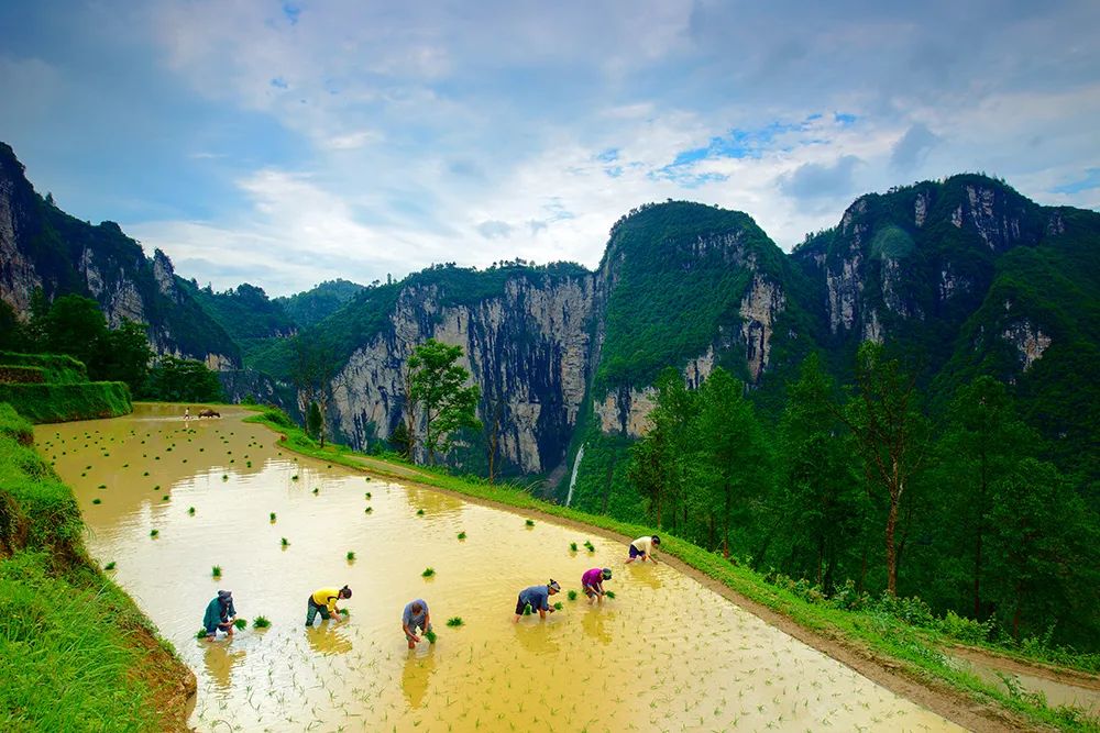
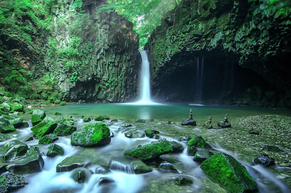
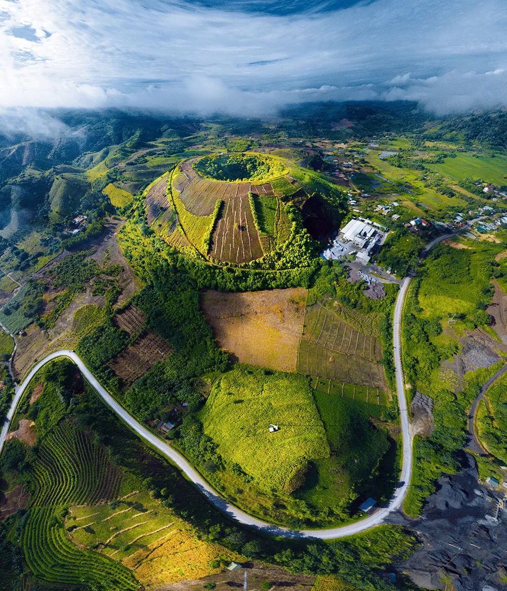
湘西联合国教科文组织世界地质公园(中国)
该地质公园位于中国湖南省湘西土家族苗族自治州的武陵山脉腹地,见证了始于旧石器时代的丰富人类历史,拥有160处旧石器和新石器时代的文化遗址。目前这里是土家族和苗族主要聚居地,这些民族也是湘西自治州最早的土著居民,其悠久的历史和文化造就了独特的民俗。该地区的地质记录了扬子地台的形成,这一前陆盆地经历了多期次的构造演化。在地质公园中,寒武纪地层尤为突出,有两个具有国际意义的“金钉子”(国际地层对比界线层型剖面)。该地区还以红石林、德夯大峡谷、坐龙峡和众多壮观的瀑布而闻名。
© Geopark Administration of Xiangxi Autonomous Prefecture
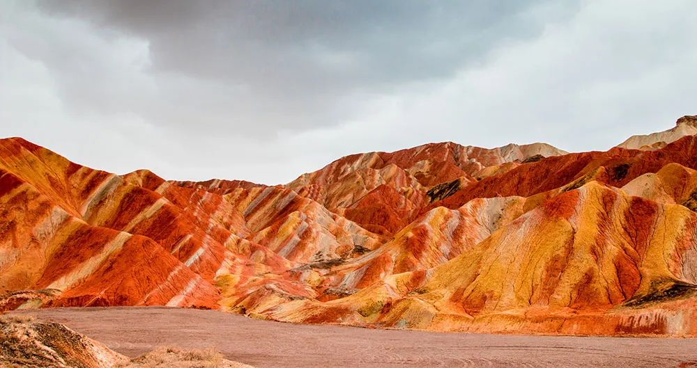
张掖联合国教科文组织世界地质公园(中国)
该地质公园位于丝路重镇甘肃省张掖市,古老的丝绸之路是连接中国与西方的贸易通道。地质公园里的577处文化景点是这座城市的历史见证,这里是包括裕固族在内的众多少数民族的家园,拥有独特的文化和生活方式。由色彩斑斓的褶皱泥岩和砂岩组成的彩色丘陵是地质公园最显著的特征。此外,还拥有自然侵蚀在山体上形成的“窗棂状”和“宫殿式”地貌,是中国丹霞地貌的最佳代表。古代洋壳残余“九个泉”蛇绿岩套是这里的另一个重要特征,其国际地质意义被众多地质学家所研究。

© Administration for Zhangye Geopark
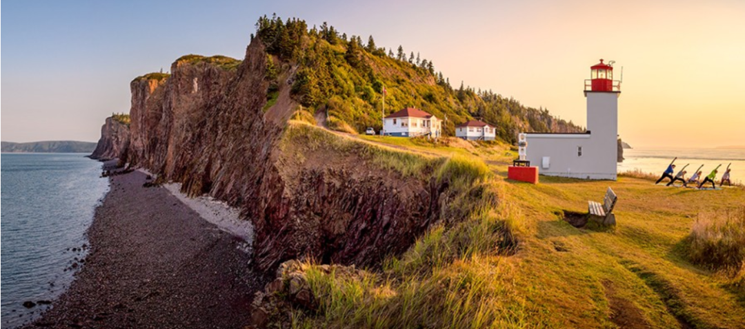
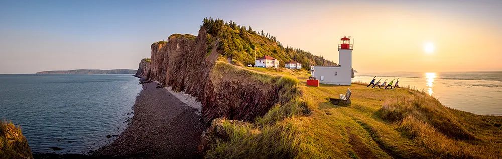
芬迪悬崖联合国教科文组织世界地质公园(加拿大)
该地质公园位于加拿大新斯科舍省米纳斯湾的北沿,具有丘陵、山脉、谷地、茂密的森林和沿海沼泽等多样化的景观,以及包括珍稀鸟类、菌类和植物在内的丰富生物多样性。米纳斯湾是芬迪湾的一个分支,这里以地球上最高的潮汐闻名,亦是地质公园的一部分。公园拥有中大西洋火成岩区域、地球历史上最大的熔岩流、早期恐龙和脊椎动物化石等。这里还是北美东北部最早的人类居住地之一,土著居民米克马克在这里生活了数千年,流传下众多关于当地地貌的传说,芬迪悬崖的居民致力于将这些故事传承给后代。
© Tourism Nova Scotia
“探索”联合国教科文组织世界地质公园(加拿大)
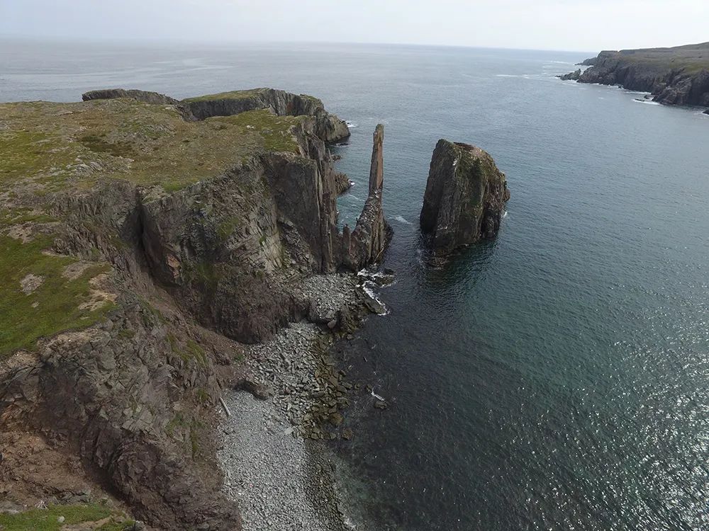
该地质公园位于加拿大东部的纽芬兰与拉布拉多省,覆盖了280公里崎岖的海岸线,海岸边有丰富的洞穴、岩拱和海床景观。公园内的遗址见证了该地区的地质变迁,这些变化也塑造了这里的土地、居民及其文化。该地区全部位于阿巴拉契亚造山运动产生的阿瓦隆尼亚地体,以新元古代的沉积、火山和深成岩的复杂组合为主体。这里的沿海地质为观察、研究和了解地球历史上最重要转变期之一埃迪卡拉纪及与之关联的动物物种变化提供了独特的条件。地质公园的岩石拥有超过十亿年的历史,是地球上一些最壮观和保存最完好的埃迪卡拉纪化石遗址的所在地。
© Geological Survey Newfoundland and Labrador, Discovery UNESCO Global Geopark
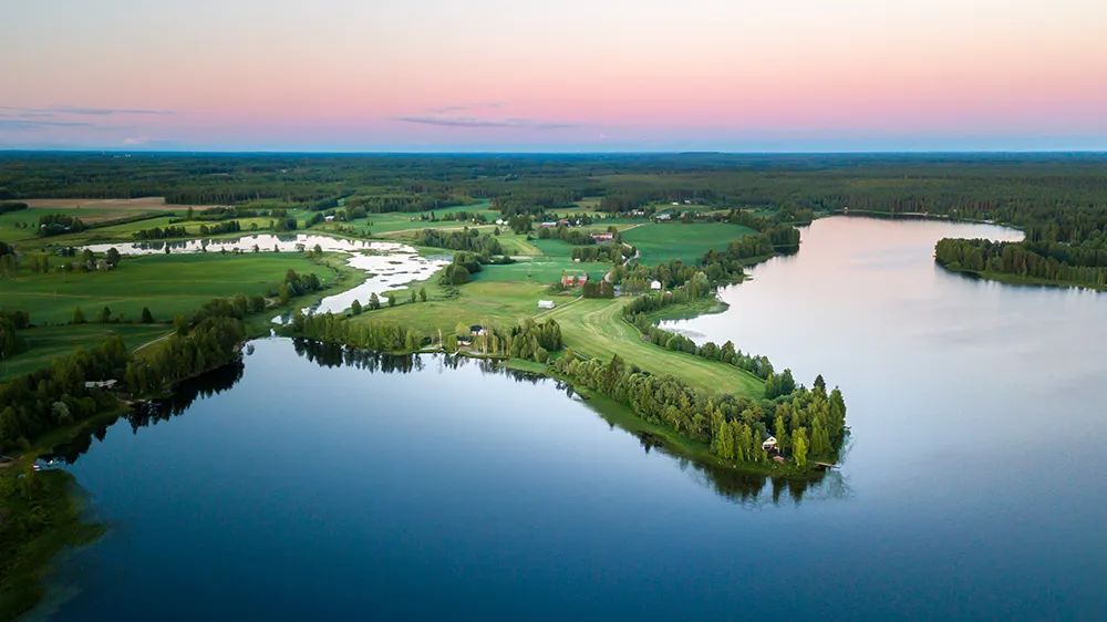
劳哈山-海门康加斯联合国教科文组织世界地质公园(芬兰)
该地质公园位于芬兰西部,由保存完好的原始泥炭沼泽组成,并拥有众多冰川和基岩结构。这些地貌讲述了该地区从山地景观到以沼泽和森林为特征的景观的远古变迁,使用该地区天然通道的众多旅行者则使这里的历史更为丰富。该地区最早的人类居住地遗址为“狼洞”,该洞穴是发现尼安德特人遗骸的最北端地点之一。自16世纪以来,贯穿地质公园的居荣康加斯通道一直是芬兰和波的尼亚湾的连接线,为当地文化中带来后来者的印记。许多古老的传统在这里得到留存,包括西欧仅存的原始啤酒萨赫蒂酒的酿造。
© Lauhanvuori-Hämeenkangas Geopark association

托巴火山联合国教科文组织世界地质公园(印度尼西亚)
苏门答腊岛上的托巴火山形成于7.4万年前的一次超级火山喷发。破火山口的积水盆地是印度尼西亚最大的火山湖,海拔904米。巨大的沙摩西岛坐落在湖中,湖的四周是起伏的山峦和平原。基底岩石在破火山口的形成过程中暴露在外,使科学家能够研究这些曾经属于超大陆冈瓦纳的土地。该地区是巴塔克-托巴、西马隆贡、卡罗和帕克帕克族人的家园,拥有丰富的文化遗产。这些遗产可以通过参观地质公园的传统民居和博物馆来探索。
© Administration of Toba Caldera Geopark, Indonesia

科科河联合国教科文组织世界地质公园(尼加拉瓜)
位于尼加拉瓜北部的科科河是火山中央山链的一部分,这里拥有连绵起伏的丘陵和平原以及小山谷。该地区的隆起和断裂地质特征为观测湿地、高地山泉和云雾森林混合地区的一系列进行中的地质构造现象提供观测点和全景图。地质公园中生长着3棵标志性的树:杏树“特雷·阿米霍”,品牌化的孪叶豆树,以及玛雅人的圣树、拥有500年树龄的金木棉。塔古西加尔巴遗产是该地区悠久历史的标志,包括众多的殖民前定居点和一些洞穴艺术实例。西班牙征服者在科科河建立了库吉金矿,并在托托加尔帕建造了抹大拉的圣马利亚教区教堂(18-19世纪)。
© Rio Coco UNESCO Global Geopark
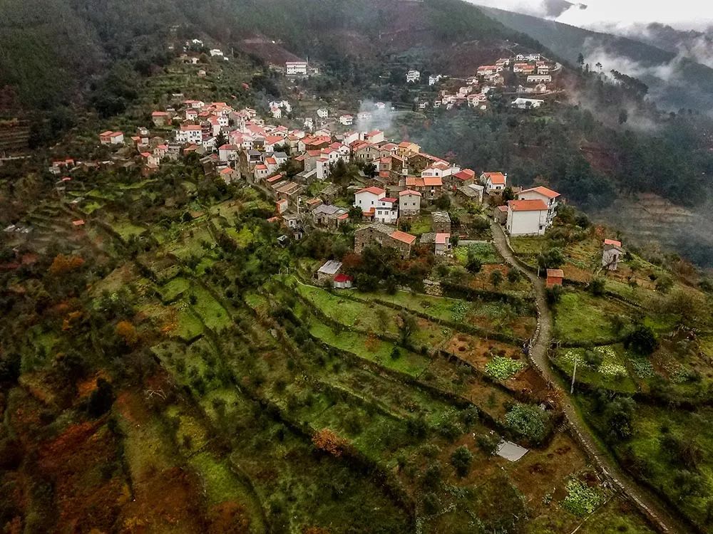
埃斯特雷拉山联合国教科文组织世界地质公园(葡萄牙)
该地质公园位于葡萄牙中部,以埃斯特雷拉山脉命名。在更新世时期,高原顶部形成了一块冰原,造就了这里独特的地质特征:冰川沉积(如拉戈阿-塞卡冰碛地),以及冰川地貌(如泽泽雷冰川谷)。地质公园还呈现出形态丰富的风化花岗岩(如科瓦多布瓦花岗岩柱,即在密集的正交裂缝网络下的一组大型天然突岩状花岗岩柱),另外还有岛山(从平面突然升起的孤立山丘或高山)等大型结构和较小的蘑菇状结构等不同形态。
© Filipe Patrocínio
汉滩江联合国教科文组织世界地质公园(韩国)
该地质公园位于朝鲜半岛中部,有着独特的火山景观。在第四纪晚期,鸭山火山喷发后释放出的熔岩流沿着原来的汉滩江河谷从平行山脉间流下,形成了铁原熔岩台地,包括深谷、玄武岩悬崖、柱状节理和瀑布。随后,汉滩江在熔岩台地上侵蚀出一条新的河道,形成了独特的火山地形。该地区拥有丰富的文化和考古遗址,其中包括可追溯到石器时代的全谷里遗迹土层,证明了该地区在贸易和战争中的战略重要性。
© Hantangang River Geopark, Republic of Korea
扬甘陶联合国教科文组织世界地质公园(俄罗斯)
该地质公园位于巴什科尔托斯坦共和国东北部的萨拉瓦特区,以其丰富的地质、动植物和文化传统多样性而闻名。地质公园三个主要的地质结构凸显了其地形丰富性:东欧地台、乌拉尔前渊和乌拉尔山脉。扬甘陶山是这里的突出地质特征之一,它有着独特的热异常,在没有岩浆活动的情况下也能形成地热泉。其它显著特征包括低地泥炭沼泽、溶洞、库尔干扎克泉、克塞利阿罗约硫磺泉和梅切特利诺地段。
© Yangan-Tau Geopark, Bashkortostan, Russia
捷尔达普联合国教科文组织世界地质公园(塞尔维亚)
该地质公园位于塞尔维亚东北部,从最古老的原生代岩石到最年轻的第四纪沉积物,该地质公园具有非常多样的地质特征。捷尔达普峡谷是欧洲最长的峡谷,也是地质公园中最引人注目的自然现象。峡谷由多瑙河冲刷而成,河水的侵蚀还形成了现在的喀斯特地貌,包括隧道洞穴、岩溶泉和天然桥(如瓦特纳天然桥)。该地区自中石器时代早期起就有人类居住,拥有丰富的文化遗产,其中包括史前遗址(莱本斯基维尔和鲁德纳格拉瓦)、罗马遗迹、中世纪堡垒、传统老房、教堂和一所修道院。这里的村庄如今居住着塞尔维亚人和瓦拉几亚人,这两个群体有着不同的文化和生活方式,世代的共同生活形成了一些融合型传统。
© Public enterprise Djerdap National Park
格拉纳达联合国教科文组织世界地质公园(西班牙)
该地质公园位于西班牙西南部,周围环绕着伊比利亚半岛上最高的几座山岳,岩层记录显示这里在第四纪曾有包括一条河流和一个湖泊的活跃水系。该地区第四纪大陆沉积物侵蚀形成山谷的记录非同一般。这些地质条件创造了当地独特的穴居景观,自中世纪以来这里的人就会居住在一种特别的传统洞穴中。如今这些洞穴被用作餐厅、旅游住宿、解说中心、酒窖等。该地区还因众多考古遗址而闻名,它们展示了了该地区丰富的历史、艺术和文化遗产。
© Alberto Tauste / Geoparque de Granada
美斯特拉格联合国教科文组织世界地质公园(西班牙)
该地质公园位于特鲁埃尔省伊比利亚山脉的阿拉贡西支处,面积广阔,涵盖43个市镇,拥有美丽的城镇和坐落在不同景观中的建筑遗产,还有着丰富的历史和庆典传统。地质公园最显著的两个地质亮点是:加尔韦的侏罗纪-白垩纪恐龙遗址——发现西班牙第一具恐龙化石的地方,和美斯特拉格区域的中生代地层——最能代表和最完整展现伊比利亚山脉白垩纪地质历史的地方之一。其他值得注意的地方还包括克里斯特洞穴自然纪念碑、雷库恩科洞穴、卡尼萨尔德洛利瓦(有颇多钙质凝灰岩建筑的市镇)和多个有恐龙化石和脚印的遗址。
© UNESCO/Laia Nebulosa Gráfica
黑郡联合国教科文组织世界地质公园(英国)
该地质公园是英格兰中心地带一处特殊的城市景观,其地质跨度长达4.28亿年,以保存完好的化石闻名。该地区丰富的煤、铁矿石和石灰岩资源激发人们发现、发明和创新,使该地区成为了工业革命的中心。这一革命还在持续塑造着现代世界。地质公园拥有各种不同的地质遗迹,包括风景地貌和观景点、废弃的矿场和采石场、运河、国家和地方自然保护区、拥有珍贵藏品的博物馆、露天旅游景点和许多历史建筑。它将我们脚下的地质同文化和工业遗产联系在了一起。
© Phil Riley
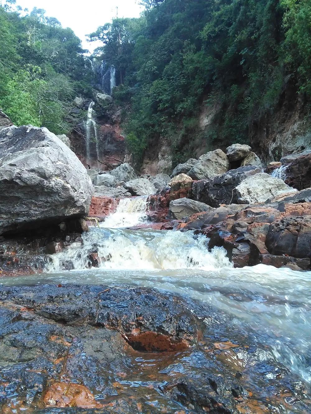
得农联合国教科文组织世界地质公园(越南)
该地质公园位于越南中央高地的得农省,其地质历史可追溯到2亿至1.65亿年前,当时这里是古冈瓦纳超大陆的一部分。几万年前的火山活动造就了该地区壮观的火山口、雄伟的瀑布和东南亚最大规模的火山洞系统,包括数百个壮观的火山洞。该地区的地质形态与多样的土壤和气候条件孕育了丰富的生物多样性和生态系统,包括许多当地特有的稀有物种。墨侬族、麻族和埃地族是这里最初的土著民族,20世纪70年代后期的移民涌入使这片土地成为40多个民族的家园,带来丰富的文化多样性。
© Dak Nong UNESCO Global Geopark
现有教科文组织世界地质公园的扩展项目:
库拉-萨利赫利教科文组织世界地质公园(土耳其)
该地质公园位于土耳其爱琴海地区东部,保留了2亿多年地球历史的证据,从古生代的变质岩到史前的火山爆发。它由3个各有特征的区域组成:库拉火山区——土耳其最年轻的火山地区之一,盖迪兹地堑——地质构造非常活跃的地区,以及博兹达山。该地质公园的特点是大片的熔岩高原、熔岩洞穴和玄武岩柱,以及与地堑形成相关的一系列形态特征,如断层、扇形沉积、与地震相关的特征等。该地质公园还具有重要的历史意义,有直立人山谷、查卡拉人类足迹化石、康卢卡亚岩画和曾经的吕底亚王国首都的墓穴(据信货币就是在吕底亚发明的),还有在约3千年前建立的萨迪斯城和公元前3世纪的阿尔忒弥斯神庙的遗址。
© Kula-Salihi Geopark
媒体联系人:
Clare O’Hagan
c.o-hagan@unesco.org
+33(0)145681729
更多信息:
联合国教科文组织世界地质公园
http://www.unesco.org/new/en/natural-sciences/environment/earth-sciences/unesco-global-geoparks
UNESCO designates 15 new Geoparks in Asia, Europe, and Latin America
Paris, 10 July—UNESCO’s Executive Boards has approved the designation of 15 new UNESCO Global Geoparks, which brings the number of sites participating in the Global Geoparks Network to 161 in 44 countries. The Executive Board also approved the extension of the Kula-Salihli UNESCO Global Geopark in Turkey.
UNESCO Global Geoparks were designated for the first time in Nicaragua, the Russian Federation and Serbia.
The newly designated Geoparks are:
Cliffs of Fundy UNESCO Global Geopark (Canada)
On the North shore of the Minas Basin in Nova Scotia, Canada, the Geopark features a varied landscape of hills, mountains, valleys, heavily forested areas, and coastal marshlands. Its broad biodiversity includes rare birds, fungi and plants. Minas Basin, an inlet in the Bay of Fundy, which is known for having the highest tides on Earth, is part of the Geopark that features exposures of the Central Atlantic Magmatic Province, the largest outpouring of lava in Earth history, fossils of early dinosaurs, vertebrates and more. The indigenous people of the region, The Mi’kmaq, have lived in the area for thousands of years, making it one of the earliest known sites of human habitation in northeastern North America. Passed down through the ages, their stories explain many geosites and the communities of Cliffs of Fundy are committed to preserving them for future generations.
Discovery UNESCO Global Geopark (Canada)
Located in Newfoundland Labrador, in the east of the country, the Geopark covers over 280 km of rugged coastline full of remarkable views on caves, arches and sea stacks. Sites within the boundary of the Geopark bear witness to the region’s geological history which has shaped the land, its human inhabitants and their culture. The area lies entirely with the Avalon terrane of the Appalachian Orogen, which is dominated by a complex assemblage of Neoproterozoic sedimentary, volcanic and plutonic rocks. The coastal geology offers a unique opportunity to observe, study, and celebrate one of the most significant transitions in Earth’s history: the Ediacaran Period, and its associated rise of animal life. With rocks over a half a billion years old, the Geopark is host to some of the most spectacular and exceptionally preserved Ediacaran fossil sites on Earth.
Xiangxi UNESCO Global Geopark (China)
In the hinterland of the Wuling Mountains in Xiangxi Tujia and Miao Autonomous Prefecture (Hunan Province), the Geopark bears witness to a rich human history starting in the Paleolithic age and features 160 cultural sites from the Paleolithic and Neolithic ages. The area is now mainly inhabited by Tujia and Miao ethnic minorities, the earliest indigenous people living in Xiangxi Prefecture, whose rich history and culture have given rise to unique folk customs. The geology of the area records the forming of the Yangtze Platform, a foreland basin that has undergone multiple stages of tectonic evolution. In the Geopark, the Cambrian system is particularly visible, with two sites of high international importance. The area is also known for its Red Stone Forest, the Dehang Grand Canyon, the Zuolong Valley, and many spectacular waterfalls.
Zhangye UNESCO Global Geopark (China)
The Geopark is located in Zhangye City, Gansu Province, which was an important township on the ancient Silk Road, trade route between China and the West. The Geopark’s 577 cultural sites bear witness to the history of the city that is home to a number of minority ethnic groups, including Yugurs, with distinct cultures and lifestyles. The most notable feature of the Geopark is the presence of colourful hills, the best example of China’s Danxia landform, formed by folded sandstones in different colours. Some of the hills have been eroded creating ‘window-lattice’ and ‘palace-style’ landforms. Another important feature is the ‘Nine-Springs’ ophiolite, a remnant of the ancient oceanic crust, which has been studied by multiple geologists for its international geological significance.
Lauhanvuori-Hämeenkangas UNESCO Global Geopark (Finland)
The Geopark, situated in the west of the country consists of exceptionally well-preserved pristine mire landscapes which are enriched by numerous glacial and bedrock formations. They tell the story of the ancient development of the region from a mountain landscape to one characterized by mires and forests. The history of the area has always been nourished by the many travelers who used the area’s natural passageways. First signs of human habitation in the region have been found at the ‘wolf cave’, one of the most northern locations with Neanderthal remains. The Kyrönkangas road, has been running through the Geopark connecting Finland to the Gulf of Bothnia, since the 16th century CE, bringing newcomers who left their mark on local culture. Many of these old traditions have been preserved, among them the manufacture of Sahti, the only primitive beer to survive in Western Europe.
Toba Caldera UNESCO Global Geopark (Indonesia)
Located on Sumatra Island, Toba Caldera was formed by a super-volcano eruption 74,000 years ago. The water-filled basin of the caldera is the largest volcanic lake in Indonesia and is situated 904 metres above sea level. The large Samosir Island rises up from the lake set amidst wave hills, mountains and plains. The creation of the caldera exposed basement rocks, enabling scientists to study what was once part of the mega continent Gondwana. Home to the Batak Toba, Simalungun, Karo and Pakpak people, the area has a rich cultural heritage which can be explored by visiting traditional houses and museums in the Geopark.
Rio Coco UNESCO Global Geopark (Nicaragua)
Located in the north of Nicaragua, Rio Coco is part of the volcanic Central Mountainous Chain featuring a landscape of rolling hills and plains with small valleys. The elevated and broken topography of the area offers lookout points and panoramic views of a range of ongoing tectonic phenomena, in a landscape of wetlands, highland springs and cloud forests. The territory is home to three emblematic trees: the almond tree of ‘Tere Armijo’, the Branded Guapino tree, and the 500-year-old Golden Ceiba, sacred for the Mayan people. The area has a rich history, marked by Taguzgalpa heritage, with numerous pre-Hispanic settlements and a few examples of cave art. Spanish conquistadors, established the Cuje gold mines in Rio Coco and built the parish church of Santa Maria de Magdalena in Totogalpa (18th and 19th centuries).
Estrela UNESCO Global Geopark (Portugal)
Located in the centre of the country, the Geopark is named after the Serra Estrela mountain range. During the Pleistocene, an ice field developed on top of the plateau, creating the features that endowed the area with its distinctive geological characteristics: glacial deposits such as the Lagoa Seca moraine field, and glacial landforms, such as the Zêzere glacial valley. The Geopark also presents a significant diversity of granite weathering forms such as the Cov vão do Boi granite columns, a large set of natural tor-like granite columns controlled by a dense orthogonal fracture network, together with different large forms including inselberge (isolated hills or mountains rising abruptly from a plane) and smaller, mushroom-shaped formations.
Hantangang UNESCO Global Geopark (Republic of Korea)
Situated in the central part of the Korean Peninsula, the Geopark features a unique volcanic landscape of deep gorges, basalt cliffs, columnar joints and waterfalls formed during the late Quaternary, after the eruption of Ori Mountain, which unleashed a lava flow between parallel mountain ranges along the old Hantangang River Valley, creating the Cheorwon Lava Plateau. Hantangang River subsequently eroded a new path through the lava plateau, developing its unique volcanic topography. The area wealth of cultural and archaeological sites including Jeongok-ri, which dates back to the Stone Age, testifies to its strategic importance for trade and war.
Yangan-Tau UNESCO Global Geopark (Russian Federation)
Located in the Salavat District in the north-east of the Republic of Bashkortostan, the area is known for the rich diversity of it geology, flora and fauna, as well as cultural traditions. Three major geological structures account for the Geopark’s varied landscape: the East European Platform, the Uralian Foredeep and the Ural Mountains. One of the outstanding geological features of the Geopark is the Yangantau Mountain with unique thermal anomalies, creating geothermal springs without the presence of magmatic activity. Other notable features include lowland peat-bogs, karst caves, the Kurganzak spring, Keselyaroyo sulfur springs and the Mechetlino section.
Djerdap UNESCO Global Geopark (Serbia)
The area, in the northeast of the country, features very diverse geology, spanning the oldest Proterozoic rocks to the youngest Quaternary sediments. The most striking natural phenomenon in the Geopark is the Djerdap Gorge, the longest in Europe. The gorge was incised by the Danube which also formed the present karst landscape of tunnel caves, karst springs and natural bridges, such as the Vratna natural bridges. Inhabited since the early Mesolithic, the area is home to a rich cultural heritage which includes prehistoric sites (Lepenski Vi and Rudna Glava), Roman remains, medieval fortresses, old traditional houses, churches and a monastery. Villages are nowadays inhabited by Serbs and Vlachs, two groups with different cultures and ways of living, which have created some mixed traditions through the ages.
Granada UNESCO Global Geopark (Spain)
Located in the south-west of the country and surrounded by some of the highest mountains of the Iberian Peninsula, the area contains stone evidence of the geological history of a river and a lake that were active in the Quaternary. It is marked by an extraordinary record of continental Quaternary sediments which eroded and formed valleys. These processes created a unique troglodytic landscape, with a singular type of traditional cave-houses, inhabited since the Middle Ages, which now house restaurants, tourist accommodations, interpretation centres, wine cellars, etc. The area is also known for its many archaeological sites that showcase the region’s rich historical, artistic and cultural heritage.
Maestrazgo UNESCO Global Geopark (Spain)
In the province of Teruel, within the Aragonese western branch of the Iberian Mountain Range, the Geopark’s extensive territory encompasses 43 municipalities with beautiful towns and built heritage set in varied landscapes, home to a rich history and traditional celebrations. The two most notable geological highlights of the Geopark are: The Jurassic-Cretaceous dinosaur sites in Galve where the first dinosaur in Spain was found, and the Mesozoic series in the Maestrazgo area, one of the most representative and complete exposures of the Cretaceous geological history of the Iberian Mountain Range. Other remarkable sites include the Cristal Caves Natural Monument, El Recuenco cave, Cañizar del Olivar (Calcareous tuff building) and multiple dinosaur sites with fossils and footprints.
The Black Country UNESCO Global Geopark (United Kingdom)
The Geopark is a special urban landscape in the heart of England with geology spanning 428 million years that is well known for its exceptionally well-preserved fossils. The Black Country is also rich in coal, ironstone and limestone, resources which inspired discovery, invention and innovation and placed the region at the centre of the Industrial Revolution which continues to shape the modern world. The Geopark boasts a range of varied geosites including landscapes and viewpoints, disused mines and quarries, canals, national and local nature reserves, museums with spectacular collections, open air visitor attractions and many historic buildings. It connects the geology under our feet with cultural and industrial heritage.
Dak Nong UNESCO Global Geopark (Viet Nam)
Located in Dak Nong Province in the Central Highlands, the Geopark’s geological past goes back 200 to 165 million years when the area was part of the ancient Gondwana supercontinent. More recent volcanic activity a few tens of thousands of years ago have endowed it with spectacular craters, majestic waterfalls and Southeast Asia’s most extensive system of hundreds of magnificent volcanic caves. Its geological morphology and varied soil and climatic conditions, are home to a rich range in biodiversity and ecosystems, including many endemic rare species. Dak Nong was originally inhabited by three indigenous peoples, the M’Nong, Ma and Ede. Following an influx of immigrants in the late 1970s it has become the home of over 40 ethnic groups and a place of rich cultural diversity.
Extension of an existing UNESCO Global Geopark:
Kula-Salihli UNESCO Global Geopark (Turkey)
Located in the eastern part of the Aegean Region of Turkey, the Geopark contains evidence from more than 200 million years of earth history, from Paleozoic metamorphic rocks to prehistoric volcanic eruptions. It encompasses three distinct areas: the Kula volcanic province: one of the youngest volcanic fields in Turkey, the Gediz Graben: a very tectonically active region and the Bozdağ Mountains. The Geopark features a large lava plateau, lava caves and basalt columns together with the range of morphological features associated with the formation of a graben, such as faults, fan deposits, earthquake related features, etc. The Geopark is also of great historical significance with Homoerectus Valley, the Çakallar human footprint fossils, the Kanlıkaya rock paintings and the tumulus tombs of what once was the capital of the kingdom of Lydia, where money is believed to have been invented, the ruins of Sardis, founded nearly 3,000 years ago, and of a temple dedicated to Artemis in the 3rd century BCE.
Media contact:
Clare O’Hagan
c.o-hagan@unesco.org
+33(0)145681729
More information:
UNESCO Global Geoparks
http://www.unesco.org/new/en/natural-sciences/environment/earth-sciences/unesco-global-geoparks
